| Allegato | Dimensione |
|---|---|
| 2.43 MB |
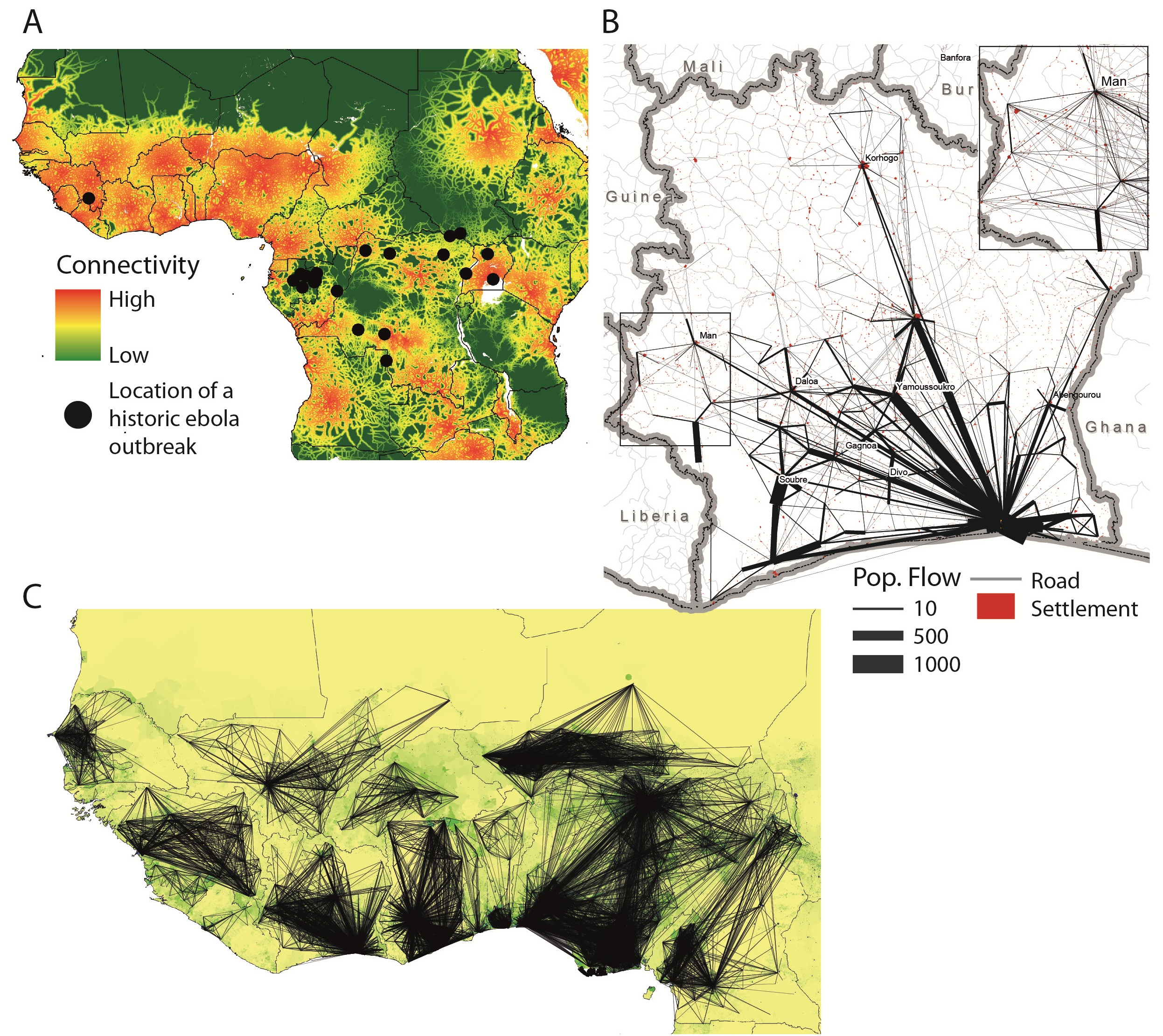
Una ricerca pubblicata su Plos può aiutare a riposndere a una delle questioni principali dell'attuael epidemia di ebola: perché è diversa dalle altre? Ebola ha un indice di contagio, R0, relativamente basso e finché il virus è rimasto confinato in zone in cui la popolazione è poco densa e connessa i contagi non si sono estesi oltre i confini di queste zone. Superata questa barriera ebola si è spostato nelle zone dell'Africa dell'ovet altament econnesse e densamente popolate. A) Map showing the location of Ebola outbreaks in humans since 1976 (black dots) overlaid on a map of strength of connectivity measured by travel time to the nearest settlement of population 500,000 or more, with dense areas of low travel time indicative of high connectivity. No previously recorded Ebola outbreak has ever occurred in such a densely populated and large area of high connectivity as the ongoing outbreak that began in Guinea.
La connettività della rete sociale è stata descritta analizzando i dait proveniente dalle reti cellualri.
B) Visualization of the flows of 500,000 mobile phone users between the (population-weighted) centres of sous-préfectures in Cote d’Ivoire. The inset highlights the mobility in the western border region (main figure: flows above 20 km with more than 10 average movements per day included, inset figure: flows above 20 km with at least one movement on average per day included);
The ongoing Ebola outbreak is taking place in one of the most highly connected and densely populated regions of Africa (Figure 1A). Accurate information on population movements is valuable for monitoring the progression of the outbreak and predicting its future spread, facilitating the prioritization of interventions and designing surveillance and containment strategies. Vital questions include how the affected regions are connected by population flows, which areas are major mobility hubs, what types of movement typologies exist in the region, and how all of these factors are changing as people react to the outbreak and movement restrictions are put in place. Just a decade ago, obtaining detailed and comprehensive data to answer such questions over this huge region would have been impossible. Today, such valuable data exist and are collected in real-time, but largely remain unused for public health purposes – stored on the servers of mobile phone operators. In this commentary, we outline the utility of CDRs for understanding human mobility in the context of the Ebola, and highlight the need to develop protocols for rapid sharing of operator data in response to public health emergencies.
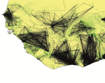
C) Outputs of a within-country mobility model for West Africa built on mobile phone CDRs. The lines show the flows predicted to be greater than 75-95% of the estimated flows per country between settlements for the average number of trips per week and are overlaid on a map of population density (www.worldpop.org.uk).
